Crispin’s
Guide to Stirling Cycling – Off-Road
Riding up the back side of
Andrew Gannel
(Blackford to Tillicoultry
across the Ochils) 7th April,
2002
I had been meaning to do this ride for yonks, as
have many other riders that I know.
Well, now you have no excuse because I have gone out
and checked the route for you.
It was a fantastically clear and sunny day, although
an overnight frost meant it was a touch chilly at first. I rode over Sherrifmuir by road, climbing up
past Logie church (Multimap link). On dropping down to Blackford, a farm-track
to the south side of the A9 took me to start of the track to Glen of Kinpauch,
which starts opposite the distillery (Multimap link). Chainsuck resulted in my chain snapping and
I also got cooked on the climb, but otherwise this is an easy LandRover track
up and up. Reaching the top, a track
continued up on my left, but it was obvious that the route across the Ochils
continued straight on. Some superb
single-track led me down to Upper Glen Devon reservoir – which was glistening
like a jewel in the sun. I stopped and
chatted to a hill walker at this point, and as he demonstrated his new 6Mpixel
camera to me we discussed how to get round the reservoir.
The route from Blackford to Tillicoultry is
signposted around the south side of the reservoir (Multimap link). However, I had tried this route before with
George and Margaret Berwick and it was extremely hard work, with an ill-defined
path and steep river crossings. The
hill walker confirmed this was still the case.
I chose today to round the reservoir to the north and this was the right
decision. No track was immediately
obvious, but after a short climb I managed to pick one up and ride most of the
way round before walking down a steep bank to the road at the far end of the
reservoir. It may well be that by
taking the track up the left I mentioned earlier, you could stay high and
circuit the reservoir with minimal problems.
At Backhills farm, the track to Tillicoultry is
picked up just before a small bridge leading to the farm – there is a sign for
Blackford here too. Keep on the track,
crossing a burn before you start to climb to the ridge. From here, I stayed on the ridge, climbing
and bog-trotting in equal measure.
Frandy Moss and Middle Hill are on your left, with Broich burn and Grodwell
hill to your right. I walked most of
the latter sections, as the grass made riding extremely hard work and I was
becoming increasingly concerned about my chain. Walking this section also gives you the excuse to stop and look
at the view to the north and east.
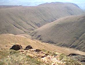
After Skythorn hill, and on crossing a second fence, Andrew Gannel hill
is way up on your right. I opted to bag
the peak, but it is possible (and very tempting) to continue straight on to
Tillicoultry. This is the route used by
the Right of Way (Multimap Link).
Looking down to Tillicoultry from the summit of Andrew Gannel hill.
The descent runs down the side of the far hill
Having eaten the remains of my jam sandwiches, I had
a massive downhill to look forward to.
I rode down the shoulder of the hill to rejoin the main path, splashing
across Gannel burn, and then descending on superb single track: a 12-inch wide
path, with just enough width for pedals, twisting and turning its way down the
hill. It continued like this, getting
wider inch-by-inch, all the way down to the top of Tillicoultry Glen. Superb.
I was able to ride more than 95% of it.
At Tillcoultry Glen, rather than dropping into the glen I continued
straight on. This was a mistake as the
large number of ramblers prevented me from getting a good run at the long
flight of steps down into Tillicoultry.
After too much carrying, and having drained the last of the water from
my hydropak, I was finally on tarmac for the ride home.
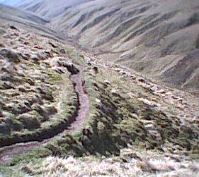
Single track descent
In total, this ride took me over 6 hours from
Stirling and I used my mountain bike (Specialized Rockhopper) with 9 miles of
off-road riding. My previous jaunt
round Upper Glen Devon was on my Trek 520 touring bike and George &
Margaret Berwick were on their tandem – most people would find a MTB to be the
more appropriate bike. To Blackford was an hour and a half, to Upper Glen Devon
another hour, with it taking 40 minutes to get round the reservoir. From the reservoir to Tillicoultry was a
hard 3 hours, with only minimal breaks.
If you do this ride, take plenty of food and water. I used a 1:25,000 OS Explorer map (sheet
366, issue 2001) and found it contained clear, accurate information on the
paths.
In conclusion, an excellent route, although also
extremely hard work. For next time, it
might be even more fun in the opposite direction as most of the track up to
Andrew Garnell hill could probably be ridden and this would then allow you to
descend all the way to Upper Glen Devon reservoir and on to Blackford.
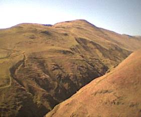
Looking up at the Law. Another day’s ride.
For more
information on this route: check out http://www.scottish-towns.co.uk/perthshire/auchterarder/walks/blackford.html
© Crispin Bennett, 2002